

Data-Backed Guide to Milwaukee’s Highest-Risk Roads, Intersections & Corridors, Plus the Defensive Driving Tips That Keep You Safe
Milwaukee drivers navigate some of the most statistically dangerous roads in the entire state of Wisconsin every single day, many of them without realizing it. Five of the nine deadliest road stretches in Wisconsin are located in Milwaukee.
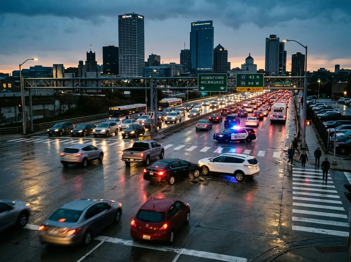
Milwaukee County’s fatal crash rate has climbed faster than almost anywhere else in the state since 2014, averaging 81 fatal collisions and 464 serious injury accidents per year between 2018 and 2022 according to Milwaukee County Department of Transportation data. And the same corridors, intersections, and highway stretches appear in crash reports, police data, and injury statistics year after year.
This is not a list designed to alarm anyone, it is a list designed to inform. Knowing which roads carry the highest accident risk, understanding why those specific locations are dangerous, and applying targeted defensive driving habits on them is genuinely protective. Awareness is a driving skill, and on Milwaukee’s highest-risk corridors, it is one of the most important ones you can develop.
Each entry in this guide covers what the data shows about crash frequency and severity, the specific hazard factors that make that road or intersection dangerous, and practical safety tips specific to that location. At the end, a comprehensive set of Milwaukee traffic safety tips applies to all seven roads and to high-risk driving situations across the city.
Related Article: Milwaukee Snow Emergency Rules Explained
| Important Note on Data: The crash data and statistics referenced in this article draw from Milwaukee Police Department crash reports, Milwaukee County Department of Transportation data, Wisconsin Department of Transportation fatal crash studies, and documented legal and safety research. Individual crash counts vary by reporting period. The purpose of this guide is safety awareness, not legal advice. |
Road #1: Capitol Drive / West Fond du Lac Avenue / 51st Boulevard, The Triple-Threat Intersection
If Milwaukee has a single most dangerous intersection cluster, it is the area where West Capitol Drive, West Fond du Lac Avenue, and 51st Boulevard converge on the city’s northwest side. This is not a single intersection, it is a chain of overlapping, high-traffic junctions in close proximity, each feeding dangerous conditions into the next.
Documented crash data shows this cluster records approximately 81 collisions annually. The Fond du Lac/Capitol/51st point alone accounts for roughly 43 crashes per year, with about 12 of those being hit-and-runs.
A nearby school, multiple fast-food outlets, and a high-speed arterial road design that encourages aggressive driving combine to make this one of the most persistently dangerous zones in the city.
Why This Corridor Is So Dangerous?
Fond du Lac Avenue runs diagonally through the northwest side, creating the kind of awkward three-way intersections that confuse drivers unfamiliar with the area.
The angles create poor sight lines for turning vehicles, and the wide lanes invite highway-speed behavior on what are effectively neighborhood arterials. Capitol Drive is one of Milwaukee’s longest east-west corridors a broad, multi-lane road that runs for miles with relatively few obstructions, generating exactly the kind of long straightaways that encourage speeding and aggressive lane changes.
The result is an area where high-speed through-traffic, local turning movements, pedestrian activity near businesses, and school-zone proximity all intersect simultaneously. Milwaukee County DOT has identified this cluster as a priority for redesign and reconstruction, with plans underway to address the geometry that creates the hazard.
Safety Tips for This Area
- Treat every green light on Capitol Drive as a conditional right-of-way, cross-traffic running reds is a documented pattern here; pause briefly and scan before proceeding.
- Approach Fond du Lac intersections at reduced speed, the diagonal alignment creates blind spots that only become clear as you enter the intersection.
- Be especially alert for pedestrians and cyclists near businesses and the school zone, particularly during morning and afternoon hours.
- Avoid left turns across Capitol Drive during peak hours if alternative routes are available, the wide road and multi-lane crossing greatly increase exposure time.
Road #2: N 27th Street & W Center Street – Milwaukee’s Highest Raw Crash-Count Intersection
If frequency of crashes is the measure, no single Milwaukee intersection has more documented collisions over recent years than the corner of N 27th Street and W Center Street.
Analysis of Milwaukee Police Department collision data from 2008 through 2022 identified this intersection as the city’s most crash-prone, with 420 total reportable collisions logged over that period. In more recent single-year data, it recorded 43 collisions in one 12-month period, including 18 hit-and-run incidents.
A nearby three-point junction at N 27th Street and W Fond du Lac Avenue adds to the danger in this corridor, recording 38 collisions in recent annual data including 10 hit-and-runs. This is a sustained, statistically persistent crash concentration, not an anomaly.
Why This Corridor Is So Dangerous?
N 27th Street is one of Milwaukee’s most traveled north-south arterials, carrying heavy through-traffic across multiple neighborhoods. Where it meets Center Street, itself a significant east-west corridor, the result is a high-volume, multi-lane intersection with documented problems around signal compliance, speeding, and hit-and-run behavior.
The high hit-and-run rate at this intersection, nearly half of reported crashes in some data periods, is itself a significant risk factor. Hit-and-run crashes are overrepresented on roads where drivers expect accountability to be low, and they indicate an environment where traffic norms are less reliably enforced.
For the drivers and pedestrians who use this intersection legitimately, the implication is that other road users cannot be relied upon to behave predictably.
Safety Tips for This Area
- Approach the intersection with heightened alertness even on green, the hit-and-run rate reflects a driving culture at this location that does not reliably respect traffic signals.
- Give extra following distance to the vehicle ahead when entering from Center Street, rear-end collisions in stop-and-go traffic are common at high-volume intersections.
- If you are a pedestrian crossing at this location, make eye contact with drivers before stepping into the crosswalk, assume you have not been seen until you confirm it.
- Avoid distracted driving in this corridor, N 27th Street through this stretch rewards full attention.
Road #3: State Route 59 (W Oklahoma Avenue) – S. 1st Street to S. 76th Street
State Route 59, running east-west through Milwaukee’s south side as West Oklahoma Avenue and its extensions, is documented as the second deadliest five-mile road stretch in the entire state of Wisconsin.
Over a 20-year study period using National Highway Traffic Safety Administration data, this corridor between S. 1st Street and S. 76th Street recorded 17 fatal crashes and 18 deaths.
SR-59 intersects several other heavily trafficked roads along its length, including S. Layton Boulevard and SR-175, generating dangerous crossing points where high-speed arterial traffic from multiple directions meets simultaneously. The S. 76th Street end leads to an I-94 on-ramp, feeding highway-bound traffic into a local intersection environment.
Why This Road Is So Dangerous?
SR-59 carries state-level traffic volumes through a neighborhood environment wide lanes, relatively high speed limits, and the kind of through-traffic behavior more appropriate to a highway than a city street.
The mix of restaurants, bars, residential access points, and the state fairgrounds on the western end brings a constantly changing mix of drivers, some local and familiar with the road, some unfamiliar and navigating for the first time, some impaired after events at nearby venues.
The S. 1st Street end, with its concentration of restaurants and bars, is a documented concern for impaired driving, particularly late-night crashes. The eastern end’s I-94 connection creates aggressive acceleration and merging behavior from drivers preparing for or exiting highway-speed travel.
Safety Tips for This Corridor
- Drive SR-59 at or below the posted speed limit, the wide lanes and relatively open sight lines encourage driving faster than conditions warrant.
- Exercise extra caution at the SR-175 and Layton Boulevard cross-points, these are the most concentrated crash zones along the corridor.
- Avoid driving SR-59’s western end late at night on weekends, when the concentration of impaired drivers near entertainment venues is highest.
- When accessing I-94 from this corridor, give early, gradual acceleration, do not accelerate hard at the last moment to merge with highway traffic.
Road #4: I-94 (Exits 305A to 310B) – The Milwaukee Zoo Interchange Stretch
Interstate 94 through Milwaukee has been called one of the most dangerous highways in the region, with 115 crashes and 132 fatalities documented over a single ten-year period on the Wisconsin stretch of the highway. Within Milwaukee specifically, the segment between exits 305A and 310B, the stretch that passes through the Zoo Interchange area where I-94 meets I-41, is documented as the fifth deadliest road stretch in Wisconsin, with 16 deaths from crashes recorded on this segment.
The Zoo Interchange is one of Milwaukee’s most complex highway interchanges, handling the convergence of I-94, I-41, and multiple local arterial connections simultaneously.
The reconstruction project underway at the Zoo Interchange and the broader I-94 East-West Freeway Project have introduced ongoing lane shifts, temporary configurations, and construction zone driving conditions that add hazard on top of an already high-risk corridor.
Why This Highway Stretch Is So Dangerous?
Highway interchange crashes follow a predictable pattern: drivers weaving between lanes to position for exits, speed differentials between merging and through traffic, reduced reaction time at highway speeds, and confusion caused by complex signage in multi-level interchange environments.
The Zoo Interchange amplifies all of these factors through its sheer complexity, multiple levels, several simultaneous route choices, and some of the highest traffic volumes in Wisconsin.
Construction zone driving adds additional hazard. Lane narrowing, shifted lane alignments, concrete barriers in place of open shoulders, and reduced emergency stopping room all contribute to elevated crash risk in active construction zones.
Wisconsin law establishes doubled fines for speed violations in construction zones, a reflection of the documented elevated risk.
Safety Tips for I-94 Through Milwaukee
- Check WISDOT and 511wi.gov for construction-related lane changes before entering this stretch, the configuration changes regularly during the ongoing I-94 reconstruction project.
- Increase following distance significantly on highway stretches, at 65 mph, every car length of following distance is only about half a second of reaction time.
- Choose your exit lane early, do not make last-second lane changes across multiple lanes to reach an exit in the interchange.
- In wet or winter conditions, reduce highway speed to 50 mph or below when road surfaces are compromised, the distance required to stop from highway speed on wet pavement is dramatically longer than on dry.
Road #5: State Route 57 (N. Teutonia Avenue / N. 35th Street Area) – W. Pierce St. to W. Capitol Dr.
State Route 57 through Milwaukee’s north side, including the N. 35th Street and W. Capitol Drive intersection and the broader Teutonia Avenue corridor, ranks sixth on Wisconsin’s list of deadliest road stretches, with 15 fatal collisions and 17 deaths documented over the study period.
In more recent annual crash data, the intersection of N. 35th Street and W. Capitol Drive alone recorded 41 crashes in one 12-month period, including 18 hit-and-run incidents.
N. Teutonia Avenue and W. Willard Avenue, nearby in this corridor, records approximately 275 collisions in the long-term MPD dataset, making it the third most crash-prone intersection in Milwaukee by raw count.
Why This Corridor Is So Dangerous?
Capitol Drive, as already noted in the first entry of this guide, is a long, wide arterial that encourages high-speed driving behavior across its entire length.
Where it meets N. 35th Street, another north-south corridor with significant through-traffic, the combination of multiple lanes, high speeds, and the commercial activity of nearby gas stations and businesses creates a high-collision-potential environment.
SR-57’s north-south alignment through this area carries state highway traffic through densely populated neighborhoods where pedestrians, cyclists, and local turning movements are common. The mismatch between the road’s state highway design optimized for traffic flow and its neighborhood context, requiring constant attention to vulnerable road users, is a recurring theme on Milwaukee’s most dangerous corridors.
Safety Tips for This Corridor
- Slow down approaching the N. 35th and Capitol intersection from all directions, the wide road design creates a false sense that high speed is safe here.
- Watch specifically for drivers running the light from Capitol Drive, this intersection has a documented pattern of signal non-compliance.
- On Teutonia Avenue, give extra space to cyclists, the road lacks dedicated bike infrastructure in many stretches, pushing cyclists into the traffic lane.
- Avoid using gas station and business access points on Capitol Drive during peak traffic periods, the cross-lane movements involved in these entries and exits are a significant crash contributor.
Road #6: Highway 100 (Mayfair Road) & Capitol Drive, Wauwatosa – The County’s Most Dangerous Suburban Intersection
Just outside Milwaukee’s city limits in Wauwatosa, the intersection of Mayfair Road (Highway 100) and Capitol Drive is consistently ranked among the most dangerous intersections in Milwaukee County.
Milwaukee County Department of Transportation data identifies it as one of the five worst intersections in the county by injury crash rate, a designation based on crashes that result in documented physical injury rather than property damage alone.
This intersection sits at the boundary between suburban and urban driving environments. Highway 100 carries traffic that behaves as though it is still on a high-speed arterial even as it transitions through dense commercial development. The combination of suburban road design wide lanes, minimal pedestrian infrastructure and high retail traffic generates a persistently dangerous mix.
Why This Intersection Is So Dangerous?
Speed is the primary contributing factor at this location, according to Milwaukee County DOT. Highway 100 funnels fast-moving traffic into an intersection where left turns, pedestrian crossings, and access to shopping centers all demand lower speeds and greater attention.
Drivers habituated to the higher speeds appropriate for the highway stretches of Road 100 do not always reduce speed adequately when the environment changes.
Poor visibility caused by the alignment of medians, parked cars on approach, and inconsistent lighting makes left turns across this intersection particularly risky.
The sight lines a driver needs to safely clear a multi-lane left turn are partially obstructed by infrastructure design, a geometric hazard that exists independent of driver behavior.
| A Pattern Across Milwaukee’s Most Dangerous Roads: Across nearly every road on this list, traffic engineering studies identify the same cluster of factors: wide lanes that encourage speeding, complex intersection geometry that creates blind spots, high traffic volumes that reduce reaction time margins, and a mix of vehicle types and vulnerable road users in the same space. Understanding these structural factors, not just driver behavior, helps you anticipate danger rather than simply react to it. |
Safety Tips for This Intersection
- Reduce speed proactively when approaching Mayfair Road from Highway 100, do not wait for the intersection to appear before reducing from arterial speed.
- Left turns across this intersection require extra caution, pull fully into the turn lane, look beyond the first lanes of oncoming traffic to confirm all lanes are clear before committing.
- In low-light conditions, treat this intersection with the same caution as a poorly lit rural crossing, the lighting is inconsistent and pedestrian visibility is limited.
- Check your mirrors and blind spots before making any lane change on Mayfair Road approaching this intersection, the wide lanes and high traffic volumes create blind-spot risks.
Road #7: State Route 175 (W. Center St. to W. Bobolink Ave.) – The Quiet Danger
State Route 175m running through Milwaukee’s northwest quadrant, rounds out Wisconsin’s top nine deadliest road stretches at number nine, with seven fatal crashes documented on the segment between W. Center Street and W. Bobolink Avenue. While the raw fatal crash count is lower than some other entries on this list, SR-175’s place on the state’s deadliest corridors reflects a sustained pattern of serious-injury and fatal crashes on a road that many Milwaukee drivers use as a routine commuter route without recognizing its elevated risk.
The intersection of N. 35th Street and W. Center Street nearby, the second-most crash-prone intersection by raw count in the long-term MPD dataset with 286 documented collisions, adds to the hazard concentration in this part of the northwest side.
Why This Road Is So Dangerous?
SR-175 combines the characteristics that define Milwaukee’s most dangerous corridors: state highway designation with a neighborhood context, relatively high speeds alongside pedestrian and cyclist activity, and multiple cross-street intersections with other high-volume arterials.
The W. Center Street end brings this road into contact with one of Milwaukee’s busiest east-west corridors, and the traffic volumes and behaviors appropriate for Center Street carry over into SR-175 in ways that increase crash risk.
The road’s relative unfamiliarity compared to more prominent corridors like Capitol Drive or I-94 may contribute to a lower level of defensive vigilance among drivers who have not been warned about it making this entry an especially valuable one for Milwaukee drivers to know.
Safety Tips for SR-175
- Treat SR-175 with the same deliberate caution you would apply to a recognized high-risk road, its state highway designation means higher speeds and more complex intersections than a typical residential street.
- The W. Center Street intersection deserves particular attention, approach it at reduced speed and confirm cross-traffic has stopped before proceeding on green.
- Watch for pedestrians crossing SR-175 between intersections, the road’s width and speed characteristics create significant pedestrian risk.
- If your daily commute uses SR-175, consider whether alternative routes on lower-volume residential streets are available for portions of the journey.
Stranded or in an Accident on a Milwaukee Road? MG Towing & Recovery – 24/7 Emergency Towing & Roadside Assistance, Milwaukee. Call Now: 414-973-1902
Defensive Driving Tips for Milwaukee’s Most Dangerous Roads
Every road on this list carries specific hazards, but a set of defensive driving habits applies universally across Milwaukee’s high-risk corridors. These are not generic safety platitudes, they are targeted practices that directly address the most common crash patterns on Milwaukee’s most dangerous roads.
Treat Every Green Light as a Question, Not a Permission
Red-light running is one of the most documented crash patterns at Milwaukee’s most dangerous intersections. A green light tells you that you have the legal right of way, it does not tell you that the intersection is physically clear.
The most effective single habit for intersection safety on Milwaukee’s high-risk corridors is a half-second pause and left-right scan before entering an intersection on green, particularly on Capitol Drive, N. 27th Street, and SR-59. This costs you almost nothing in travel time and catches the red-light runners before they reach you.
Match Your Speed to the Environment, Not the Limit
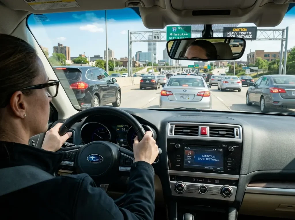
Posted speed limits reflect maximum legal speed under ideal conditions. On Milwaukee’s wide arterials, driving at the speed limit during peak hours, in wet conditions, or at night means driving faster than the environment actually supports.
The crashes that happen on Capitol Drive, SR-59, and Highway 100 are heavily concentrated among drivers traveling at the speed limit or above in conditions that warrant lower speeds. The defensive driver’s rule is simple: the limit is a ceiling, not a target.
Eliminate Distracted Driving on High-Risk Corridors
The combination of high traffic volume, complex intersection geometry, and aggressive driving behavior on Milwaukee’s most dangerous roads means that the margin for error is smaller than on quieter streets.
Distracted driving, phone use, eating, adjusting navigation, on these specific corridors removes the reaction time buffer that allows a driver to avoid a crash that is developing. If you need to address something in the car, do it before you reach a high-risk corridor or pull off the road entirely.
Increase Following Distance Dramatically in High-Risk Zones
Following distance is reaction time. At 40 mph, three car lengths gives you approximately two seconds to respond to a sudden stop or obstacle.
On Milwaukee’s busy arterials, where sudden stops for turning vehicles, pedestrians, and signal changes are constant, two seconds is barely adequate.
The standard recommendation of three to four seconds following distance increases your reaction buffer to the point where you can respond to most sudden situations without a collision.
Know When and How to Avoid the Most Dangerous Roads
Awareness of which roads carry the highest risk gives you the option to route around them when the additional exposure is not worth it. For non-time-sensitive trips, errands, recreational drives, avoiding Capitol Drive’s most dangerous stretches in favor of residential parallels like North Avenue or Lisbon Avenue eliminates risk entirely.
GPS navigation apps will rarely route you onto a high-risk arterial voluntarily, but you can set them to avoid highways or specify residential routes when you have the time to use them.
Quick Reference: Milwaukee’s 7 Most Dangerous Roads at a Glance
| # | Road / Location | Primary Hazard | Key Safety Action |
| 1 | Capitol Drive / Fond du Lac / 51st Blvd | Diagonal geometry, speeding, hit-and-runs | Pause before entering on green; watch turns |
| 2 | N. 27th St & W. Center St | Highest raw crash count; frequent hit-and-runs | Full intersection scan; assume red-runners |
| 3 | SR-59 (W. Oklahoma Ave), S. 1st to S. 76th | 2nd deadliest state road stretch; impaired drivers | Reduce speed; extra caution late night |
| 4 | I-94, Exits 305A–310B (Zoo Interchange) | Complex merge; construction zone; high speed | Check 511wi; early lane selection; increase gap |
| 5 | SR-57 / N. 35th St & Capitol Drive area | State highway speed through neighborhood | Slow for Capitol crossing; watch pedestrians |
| 6 | Hwy 100 / Mayfair Rd & Capitol Dr, Wauwatosa | Speed mismatch; poor left-turn visibility | Reduce speed early; extra caution on left turns |
| 7 | SR-175, W. Center to W. Bobolink Ave | Underappreciated state highway danger | Treat like a known high-risk road; slow at Center St |
Frequently Asked Questions: Milwaukee Road Safety
Why does Milwaukee have so many dangerous roads compared to the rest of Wisconsin?
Milwaukee is Wisconsin’s most populated city, and higher population density means more vehicles, more intersections, more pedestrian activity, and more conflict points per mile of road. But population alone does not explain the full picture.
Milwaukee County’s fatal crash rate has climbed faster than other parts of the state since 2014, a trend driven in part by an increase in reckless and high-speed driving behavior, particularly on the wide arterial roads that characterize the city’s northwest and south sides.
The Milwaukee County DOT has identified this as a crisis requiring both engineering solutions (road redesign, speed humps, curb bumpouts) and enforcement responses.
What is Milwaukee doing to make these roads safer?
The City of Milwaukee has invested approximately $86 million in street safety projects in recent years under a Vision Zero program focused on re-engineering high-crash corridors. Specific measures include installing curb extensions (bumpouts) that narrow the road and force slower turns, installing speed humps on residential streets, and redesigning the most dangerous intersection geometries.
Milwaukee County DOT has active plans to redesign the Fond du Lac/Capitol cluster. The I-94 East-West Freeway reconstruction project is also under active construction. City officials have also advocated for speed cameras, which state law currently prohibits.
What should I do if I’m in an accident on one of these roads?
Move the vehicle to a safe position off the travel lane if possible without risk of further collision. Turn on hazard lights immediately. Call 911 for accidents involving injury, significant damage, or blocked traffic lanes.
Document the scene with photographs before moving vehicles. Exchange insurance and contact information with other involved parties. If your vehicle requires towing, call a trusted Milwaukee towing provider, MG Towing & Recovery is available 24 hours a day and can dispatch to any Milwaukee location. Never leave the scene of an accident.
Are these roads more dangerous at certain times of day?
Yes, distinctly so. The Capitol Drive corridor and N. 27th Street area see the highest crash concentrations during afternoon and evening rush hours, when traffic volumes are at their peak. SR-59’s western end near its restaurant and bar concentration sees elevated crash risk late at night and particularly on weekend evenings.
I-94 crash risk is elevated during morning and evening peak commuting hours and during winter weather events. Knowing the peak risk periods for your specific route helps you time trips to avoid them when possible.
If I break down or get into an accident on one of these dangerous roads, what should I do?
Your first priority is getting clear of traffic. If the vehicle can be moved, move it to the shoulder or a side street. If it cannot be moved, stay inside with your seatbelt fastened and hazard lights on, exiting a disabled vehicle on a high-speed Milwaukee arterial or highway is more dangerous than remaining inside in most situations.
Call 911 if there is any injury or if the vehicle is blocking traffic. Call MG Towing & Recovery for 24/7 emergency towing and roadside assistance in Milwaukee. Our local dispatch reaches you faster than national programs, and we know Milwaukee’s high-risk corridors and how to safely position recovery vehicles on them.
